Showing posts with label camping. Show all posts

Wednesday, August 28, 2013

Running from the Fire-Into the Arizona Frying Pan! (#31)

There's gonna' be some trouble around here! - Tombstone, AZ
Miller Fire-SE Arizona
On the first leg of our Vegas Loop trip in 2011 we entered Arizona on I-10 from New Mexico.  We stopped at the first rest area to pick up tourist information and a map, but only found a few kiosks.

What we did see to the south was smoke and it turned out to be the first of several progressively worse fires until the Sierra Vista fire which chased us to the Phoenix area a day ahead of schedule.

Next stop was a visit to Tombstone.  We got off of I-10 at Benson and missed our left turn to head south on Arizona 80.  It was a stroke of good luck because we saw the Old Benson Ice Cream Stop sign and stopped for one of their 44 different soft serve flavors!  I had the black cherry and we were off again. Before we ventured to downtown Tombstone we stopped for a little shopping, a nice antique shop and a jeweler next door who had a super collection of fire agates. As we headed to the tourist info office downtown we watched the rumblings of the Earp brothers and Doc Holliday as they tempted the crowd to watch them finish the gunfight at the OK Corral. We then picked up a historic walking tour map and headed down Main Street.  This is a tourist trap town, but we LOVED it! We visited several shops and went into the old Crystal Palace and Big Nose Kate's Saloon to have a beer and sarsaparilla. Phil went downstairs in Big Nose Kate's to buy a souvenir t-shirt and enjoyed learning the history of "The Swamper" before we hit the road to our first Arizona campsite.
Big Nose Kate's - Tombstone
June is one of the hottest months this far south in the USA and without air conditioning camping can get quite uncomfortable. Our strategy was to camp at elevations above 5000 ft, which was a great plan...as long as the places weren't on fire.
Sky Island Scenic Byway
 We headed west on AZ 82 toward Lakeview Campground located at 5400 ft in the Sierra Vista district of the Coronado National Forest. Anticipating one of 65 scenic campsites, we turned off the main road onto one of the National Forest designated scenic drive toward the beautiful Huachuca Mountains. About 7 miles into the drive a barricade in the middle of the road stopped us...Road Closed Due to Fire. I checked my laptop for National Forest updates and another campground in the vicinity. According to the website, Lakeview was indeed closed. then I looked for a backup plan. The Santa Catalina Recreation Area northeast of Tucson wasn't showing any closures and there were six campgrounds above 5000 elevation on the 27 mile Sky Island Scenic Byway. We climbed into the mountains through a hillside of blooming Saguaro cactus as the sun began its journey into the horizon. After six miles we saw the first of the campgrounds-barricaded. I checked the website again...no postings stating it was closed. We continued on and each time, each campground was barricaded. We arrived at Summerhaven and stopped in at the trading post where they informed us the campgrounds were closed due to fires, even though we had seen no signs of smoke north of I-10. Now what were we going to do?

Mt. Lemmon Ski Area - Summerhaven
Back on the laptop (and nearing 8:30pm) I found another campground on the west side of Tucson, this time I called. The recording for Tucson Mountain Park said the gate to the Gilbert Ray Campground closed at 10pm; we had to race to get there, but got there with five minutes to spare. Tucson Mountains Park is not really in the mountains, so we woke up early and decided to retrace our route to one of the tourist stops we missed even though Saguaro National Park West adjoined this park.

Mission San Xavier del Bac-White Dove of the Desert just might be the most beautiful non-secular buildings. Completed in 1797, they boast it's the oldest extant European constructed
building in Arizona. We spent the morning here and joined one of the docent led tours before heading back into Tucson for lunch.
San Xavier Interior
The 11 beer sampler
To get my microbrewery fix in Arizona we picked the Barrio Brewing Company where I had their colossal 11 beer sampler. Both beer and food were very good especially the happy hour appetizer of Pretzel Pillows with Nuclear Mustard dipping sauce. Barrio is located in an industrial area next to the railroad tracks so listen for the train crossing guard bells which of the railroad track gates, which signal Barrio Rail Pints are $3.25! We didn't know what to do, the fires had pushed us a day ahead of schedule and did not want to go back to the heat of the previous nights campground.
I called my friend near Phoenix and she graciously invited to come a day early.


We went back through the Tucson Mountain Park to Saguaro National Park West. Shortly after entering the National Park, we turned off the main park road onto the narrow and disserted Cactus Forest Drive. This one-way road lacked traffic road making it easy to stop and watch the birds who made their home in these majestic cactus pincushions. It was late afternoon as we turned north toward Phoenix and time to jump out of the frying pan. the fires finished with the blessing and the best two days in Arizona, catching up and spending time with old cherished friends.


Saturday, August 24, 2013

America's Heartland, Part 1- Iowa (#26)

Holliwell Bridge

I have traversed Iowa both east to west and back several times. Each time I said I was going to stop and take a closer look. So on a road trip from Austin, Texas to Minneapolis, Minnesota, I finally did it.

John Wayne's Boyhood Home
I got off I-35 at mile marker 52 for a bucolic mini Bridges of Madison County tour. First was the almost immediate Imes Bridge just east of St. Charles, followed by a picturesque barn, the Holliwell Bridge and the Cutler-Donahue Bridge in Winterset, Iowa-hometown of John Wayne. Winterset is the county seat and is well worth a stop to stroll around the historic courthouse square to shop & get a bite to eat in one of the well preserved Italianate buildings from the late 1800s.

My next stop was Des Moines, Iowa's centrally located state capital. As I headed east on Grand Avenue toward the downtown I caught sight of a mansard roof topped tower and just had to turn back to investigate. Terrace Hill is the stately Governor's Mansion built in 1869 by Benjamin Allen-Iowa's first millionaire. I was fortunate to catch the day's last docent led tour before heading to experience Des Moines great selection of public outdoor art.

First stop was the 4.4 acre Pappajohn's Sculpture Park just before reaching the heart of downtown. Located just a few more blocks in Nollen Plaza is Crusoe's Umbrella, one of Claes Oldenburg's large-scale pieces.

After a very full day in America's Heartland it was time to relax and grab a pint and burger at the el Bait Shop with more than 100 craft beer taps.  I was thrilled to see several Bell's selections and after a nice conversation with my bartender decided to try the Des Moines IPA by Confluence Brewing Company.

This evenings destination was camping at Ledges State Park, recommended by the tourist information attendant just inside the Iowa border on I-35. As its name suggested, this was not the flat farmland I had driven to get there. After securing a nice non-electric site it was time to drive down into the canyon where I forded my car (Rosemary) across several little streams.
One of several stream fords
The next day I traveled several miles of the historic Lincoln Highway before findind myself back on I-35 heading north to Minnesota and looking forward to the continuation of my Iowa visit next week.


Monday, November 15, 2010

Finding "Lost Maples" in Texas (#44)


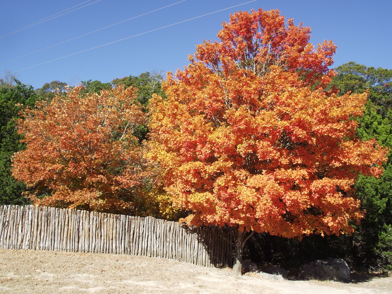
What Midwestern girl would not be intrigued by the thought of finding "lost maples" ablaze with color in Texas Hill Country? The bigtooth maple is the tree that most closely promises some of the same vibrant fall color of Michigan's glorious sugar maples. Prime time for experiencing fall color in the Texas Hill Country usually occurs near the beginning to middle of November. To commemorate my birthday we took advantage of the long Veteran's Day weekend this year and reserved a campsite at Garner State Park and headed southwest for a hiking filled weekend.

We decided to take the road a little less traveled and letterbox our way to Garner State Park. The direct route would be about three and a half hours, but there were just so many places we needed to see and food to savor! We packed up first thing Friday morning and headed up SH71 to US281 and stopped at Spicewood General Store for one of the best breakfast tacos (a central Texas food phenomena) I've ever tasted. The steam table had more that ten different items to choose from like carne guisado, charrizo, sauteed green peppers and onions besides the basic eggs, potatoes and cooked ground bacon. I topped mine off with a pico de gillo and salsa; Phil had his with cheese, both cost $5. As of 2017 there are new owners and tacos just are not what they used to be.

Our next stop was Sisterdale, reputed to have been established by German "Freethinkers" in the mid-nineteenth century. We stopped at Sister Creek Winery located in a repurposed 1885 Cotton Gin. The winery offers several choices of red and white wines and tastings for a moderate fee. As we headed north of the town center, we saw the old schoolhouse and stopped to read the RTHL marker posted on the wall. Built in 1893 the schoolhouse was constructed with huge blocks of local limestone. We turned left to continue west on RM 473 and spotted a beautiful farmstead on the rise. The entrance gate was marked Siedensticker-1855.

We continued moving southwest towards Bandera, the Cowboy Capital on scenic backroads. We made a quick stop at Camp Verde, site of U.S. War Department's 1857-69 camel experiment run by Jefferson Davis. Today all that remains is the quaint general store, in continuous business since 1857. The highly remodeled two story building holds a cafe and the mercantile store selling specialty food, gifts and a whole room devoted to modern penny candy.

After stopping in Bandera for That Genghis Guy we headed for Tarpley to have lunch at Mac and;Ernie's Roadside Eatery. Featured on the Premier episode of Diners, Drive-Ins and Dives, we asked an owner how they were picked and she shared that Guy Fieri's veterinarian hadrecommended the place to him! The place has become so popular they had to expand, but they used the old kitchen for the entry so old customers can still recognize the place. We enjoyed the recommended Cabrito Burger and French Fries, which were cooked perfectly. The eatery is only open Friday-Sunday, but it is well worth rescheduling the day and the route you take to visit this beautiful area. The lunch menu is almost exclusively limited to burgers, including an Axis (deer) burger, but dinner and Sunday are filled with gourmet faire and if you bring your own vodka they will make you a pitcher or two of some awesome Bloody Mary mix to go with your breakfast.


We soon realized that Texas does offer nice fall color in some areas. I do prefer reds and oranges. and this area has a fair amount of bigtooth maple, sycamore, red oak and persimmon. We arrived at Garner State Pair in the late afternoon and snagged a great campsite (#468) in Rio Frio; part of the new "water only" section. This site is located close to the shower building and had good tree cover to set up our tarp roof. The rest of the day was devoted to relaxing and walking along the Rio Frio and resting up for our search of the elusive lost Maples.


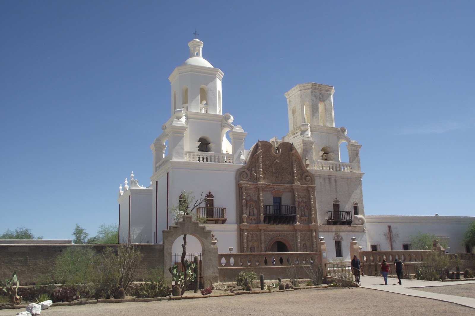
After a leisurely morning we headed east to Utopia and north to Lost Maples State Natural Area. We arrived around 10am to find a short lineup waiting to get into the park and one nasty policeman screaming and shaking his fingers at the cars....give this guy a chill pill, we are here to experience nature folks! Once inside the park we continued with lines...lines to park, lines to go in to get a tag (glad I am a Park Pass holder), another line to park. In defense of the park we were here peak fall color on the Saturday of a long Veteran's Day weekend. And for the amount of lines we really did not wait too terribly wrong...it just all seemed contra to being in a State Natural Area.

We parked in the first lot on the west and headed up the East Trail. We soon met what State Natural Area really meant...steep uphills with large, loose chunky gravel the size of golfballs. This 4.6 mile trail should not be attempted with flip-flops or kitten heels, yes we saw both, in fact I highly recommend good hiking shoes or boots that offer plenty of ankle support. The view from the top is well worth the effort it takes to get to get there!! We had packed a lunch and found a nice ledge to sit on and enjoy the view of the valley below. After finishing the trail with a thousand new friends, we headed out of the park and the mile long line of cars still waiting to get into the park at 3:30pm. I sure hope they don't think they can hike the East Trail before it gets dark.

On to Leakey for an early dinner at one of Texas Monthly's 40 Best Small Town Cafes. We arrived an hour before the Leakey Feed Lot reopened for dinner so we headed up to the scenic overlook (now closed) north of town on US 87 and enjoyed a Shiner Bock we had stashed in the cooler. This funky little cafe has varied hours that change with the season so I highly recommend checking their website link before you go. The article recommended the chicken fried rib eye, but all I could think was-Why ruin a perfectly good steak? So I had the rib eye sans the chicken fried with a side of bacon green beans and salad. My meal was delicious and my medium rare steak was cooked to perfection. Unfortunately Phil's chopped steak was overcooked to shoe leather and they served it on Styrofoam plates...I guess they don't want or have a dishwasher. To top it all off they brought the very tasty salads with croutons and cheese with our dinner, no mistake just the SOP. If I were to go again, which I might-the staff and owner were friendly and we loved the funky cafe decor-I would go for the food more appropriate to Styrofoam and have a beer. Another 40 Best nearby was Hicks House and Bakery east of Utopia on Lee Street in an old renovated house, next time will be a must stop.

We savored one last night around the fire. Sunday morning we broke camp at a leisurely pace, enjoying breakfast, hiking along the Rio Frio and plotting one last hike and the route back to Austin. We were glad we had chosen Garner over Lost Maples to camp. Lost Maples very limited campsites were out in the open and everyone using the trails had to pass by. Lost Maples would be fine for someone who had a recreation vehicle, but we like the peace and quiet without listening to generators running all night. We also liked the newer Rio Frio section of Garner because of the mature trees we like for setting up a tarp roof.

Our last hike was in the older section of Garner, south of our site. We took the trail to Crystal Cave (make sure to pick up a Hiking Trail Map on you way into the park). This trail is reminiscent of the East Trail from yesterday. Up,up,up we hiked over the same golfball sized gravel (did they import this stuff?). We climbed more than 1200 feet in elevation over a short 0.37 mile trail. Never so happy to see a cave entrance sign, we ventured into the small cave to see the crystals. Without a flashlight and feeling a little foolish (it did say crystal now didn't it?), we made due with the light from my camera and Phil's lighter. It was worth the effort to get there and next time we will bring our flashlight! Just before heading back down the boulder strewn trail we grabbed Baby Bear's Extreme letterbox Oh Crap, That Was Today. After all, I had made it this far, why not scramble up the hill another 20 feet...and as it turned out it was a super cute carving.

Leaving Garner we turned east to Utopia then north up RR187 past Lost Maples to SH 39 and headed easterly again. The road to Hunt weaves back and forth crossing the Guadalupe River numerous times. We rounded a curve to see several horses down in the river seeking a little refreshment. We stopped to take pictures and continued on our way. At Hunt we turned left to go to the old Stonehenge and Easter Island heads location. I had heard rumor they wanted to relocate the 7/8 size replica, but Phil had never seen it so I thought it was worth checking. The old field was empty, but a sign directed us to its new home just down the road in Ingram at the Point Theater.

Stonehenge and the Island Heads seemed happy in their new home and it was now time we headed to our old home. But I could not resist going through Fredericksburg and making one last stop at my favorite Texas brewpub for a light dinner and a few delicious brews. Fredericksburg Brewing Company is located downtown on Main Street smack dab in the middle of town and offers several staple beers like Not So Dumb Blonde, Enchanted Rock Red Ale, or Pioneer Porter. They also brew specialty batches and had a Fitztown Brown-their seasonal hoppy porter with a creamy head, this is a great transitional beer as we move into the colder winter months here in Texas. A perfect finish to the fantastic long weekend.

Sunday, January 24, 2010

Texas Hill Country Winter Weekend (#44)

One of our favorite getaway destinations is the glorious Hill Country here in Texas. While my favorite season tends to be the wildflower explosion during a great spring, every season reveals something special about this beautiful region. This last time we decided to try a little winter camping over the long MLK weekend.

Our first destination was the far western reaches of Hill Country and a little adventure at Caverns of Sonora. Located just west of Sonora of US 10, we knew we met West Texas went the posted speed limit went up to 80 mph. We love exploring caves and caverns and found this one to be an extraordinary gem for the spelunking crowd. The tour was almost two hours and included over 350 stairs taking us more than fifteen stories below the rugged desert above. We saw some very unique formations we had never seen before like fishtails, war clubs and geodes embedded into walls. What I found the most striking though, was the variety of formations included in each room. Both physical effort and tour cost ($20) were well worth it.

We had our choice of several very nice campsites at South Llano River State Park in Junction, but I imagine when its warm a little prior planning and a few inter tubes would be wise. There were several nice hiking trails including one straight uphill to a scenic overlook and a couple very comfy bird blinds to watch some of our fine feathered friends.

We wandered our way back home through some of the
most scenic roads I have encountered in Texas...and this was January! We headed south from the state park on RR377 and made our way toward Rocksprings, self professed Mohair Capital of the World. On our way there we stopped at Telegraph (Population 3, 2000) and admired the picturesque old general store & post office. Telegraph is an interesting little ghost town and holds the distinction of having the first commissioned postmistress in Texas in 1900.

About six miles north of Rocksprings we turned east onto 41, then south again at RR335. This was the first of two Twisted Sisters roads we would wander. The incredibly scenic road hugs the side of mountains named Schoolhouse, Graveyard and Turnpike and then crosses the Nueces and Frio Rivers. A little over half way we stopped at the fence of an exotic animal farm to watch kangaroos, giraffes and exotic antelope play. Then a few miles later we encountered a few camels. Just above Barksdale we joined 55 and followed it into Camp Wood.

At Camp Wood we turned east onto the second Twisted Sister RR337. Just before we left the town proper we had to stop at Holy Smoke BBQ who's slogan was "Never Trust a Skinny Cook!" We left with a pound of brisket and the appropriate fixings and headed down the road to find a picnic table to feast. A picnic table there was not, but the beauty of this highway begged for us to stop....somewhere. We rounded a curve and there was a small turnout overlooking the valley so we pulled over and made a make shift picnic table of our cooler. I love Texas BBQ and brisket is KING!
Just south of Leakey we headed south on US83 to Garner State Park to do a little hiking. Before leaving we checked out the extensive network of campgrounds, this park has so much to offer and is definately a must future camping trip. We headed east on 1015 to Utopia and then north on 187 to Lost Maples SNA. This time we drove right into the park, but an earlier fall visit found us several miles south of the park waiting more than an hour to enter and see the beautiful Bigtooth Maples bursing into a flame of fall color.

Heading back east on FM337 we stopped in Medina, apple capital of Texas. Here you can pick your own apples in season at Love Creek Orchards or stop in any time at the bakery store for one of their tasty apple baked goods. We loved their "Adam's Favorite Pumpkin-Pecan-Apple Bread" and Apple Strudel as a nightcap. We need to come back during apple picking time when the orchard is full of dwarf trees bearing some of my all time favorites like Jonagold and Pink Lady as well as their special "Lone Star Little Sugar" Gala.

January was a great uncrowded time to spend a lovely MLK long weekend exploring, but every season holds something special here. So come any time and if you really love fall there isn't anywhere else in Texas quite like this heavenly slice of Texas Hill Country.

Monday, May 11, 2009

Sweet Home Alabama (#45)


In June of 2007, our family was living in the twilight zone. Phil and Austin were living in the house in Michigan, while Jacob and I were living in our newly purchased house in Texas. We drove to Michigan as soon as Jacob got out of school for the summer and I "traded" vehicles with Phil so I could load up the van and head back to Texas. At this time I had been to 44 states and Washington DC and was missing three southern states. I took the opportunity and headed straight south from Michigan, picking up the Natchez Trace Parkway in Nashville and heading southwest toward Louisiana. When I got to Alabama, I turned east and headed for I-65 where I turned south toward my main destination...Birmingham.

I had read that Alabama had several covered bridges and decided to explore the east side of I-65 above Birmingham and visit a few. Most were in very haphazard shape, but one I found thoroughly intriguing near Oneonta. The Horton Mill Covered bridge is a town lattice truss bridge and considered the highest covered bridge above a US waterway towering 70 feet above the small river. Parking was very limited, so I parked out on the main road and scurried down to the bottom to see just how high this bridge really was. As I looked up from the river, I was glad I had already ventured across the bridge and back, because there was no way I was going back over it now...it looked like a covered bridge perched on toothpicks!

On my way into Birmingham I discovered one of the prettiest barns I have ever seen up on a hillside. I stopped to take pictures and the owner came over and struck up a conversation with me and offered to let me go into the barn to see the inside. He told me that the barn and property had been in his family for three generations and that they often had people from all over the US stopping to take pictures...I wasn't a bit surprised.

It had started raining by the time I found the Sloss Furnaces National Historic Landmark in Birmingham. I watched the short movie about the history of the pig smelting facility and ventured outside and took the self guided tour. It started to pour and I found myself playing hide and seek with the raindrops navigating through the various stages of pig iron smelting.


After my enjoyable tour at Sloss Furnaces, I headed to the highest point in the city to visit Vulcan. Built in 1904 as a tribute to Birmingham's iron roots, Vulcan is considered the worlds largest cast iron statue and underwent a complete multimillion dollar renovation in 1999. The park surrounding the colossal statue had a nice museum and it was a great place to picnic. The statue is open late and I thought an evening visit to the top of the 56 foot statue for a panoramic view of the city would have been another great option.

My day was fleeting fast, but I had just
enough time to head down I-59 towards Tuscaloosa for a stop at the Tannehill State Historic Park with more than forty-five historic buildings from its heyday as a bustling ironworks town. The staggering number of sites and activities included a museum, gristmill, farm, candy store and a small railroad as well as camping and cabin rentals. A great place to explore.

Sunday, May 10, 2009

Gateway to the West-Nebraska (#27)


I used to consider Nebraska a mere pass through state...A necessary evil to labor across to get to the good states, on either side. Then again I never took the time to stop here before. This time I would stop, my destinations - Carhenge, Scotts Bluff National Monument and camping at Lake Minatare SNA-Home of Nebraska's only lighthouse...my thought was that anyplace with a lighthouse couldn't be all that bad. Nebraska was so much more than I originally expected and I hope to return someday and see more of this All-American state.

My first surprise was prompted by a highway sign directing tourists to an original Pony Express Station. I ventured off I-80 at Gothenburg and followed the signs. While the Station was indeed the real deal, it had been moved from the original Pony Express Route about eight miles south of the highway. No matter, the road to the station was lined with historic homes in spring flower bloom and just off the highway was another surprise...a sod house museum. It was a quick visit but it was time to get back on the road and head to my camping destination - Lake Minatare just outside of Scottsbluff. I got hopelessly lost trying to find this lovely camping area, my GPS unit failed me and my husband Phil's attempts to direct me via cell and the Internet brought him nothing but borderline hysteria from me. What Phil had realized and I could not wrap my brain around was that there were a couple of identical intersections within Scottsbluff. Near dusk I finally found the campground with just enough time to climb to the top of the lighthouse and find a spot to bed down for the night. Ordeal over.

The GPS was back to its old
self in the morning and we arrived at Scotts Bluff National Monument just as the park road and museum were opening. After a lovely conversation with the NPS staff, I headed to the top of the bluff on Summit Road, the oldest concrete road in Nebraska they informed me. I was alone at the top, except for mule deer and a rabbit and the wind howled like a locomotive. I walked to both north and south overlooks and was astounded by the starkness the pioneers must have encountered a century and a half ago. Way off in the distance I could see Chimney Rock, a landmark pioneers used to mark their halfway point to Oregon.

I traveled back to the museum and took the path to walk part of the Oregon Trail. While researching our genealogy several years ago, we discovered that Phil's family had taken the Oregon Trail and had lived in the same two vicinities as Phil - one hundred years apart of each other. Oh what a thrill to have walked where ancestors may have walked! Interesting too was that The Mormon Trail, California Trail and Pony Express all converged here at Mitchell Pass. I had used Chimney Rock as a landmark to find my way here and the whole experience sent chills through my body.

It was time to head north with one short side trip to Alliance for
a visit to Carhenge. The town of Alliance was a quaint little town with great architecture. It was obvious this community took a lot of pride in their bustling downtown. I stopped to take pictures and a woman stopped to chat with me about the buildings and gave me a brief history of them and the town, the county seat. She told me to drive down to the county courthouse and see the decorative brackets along the roofline and I passed the old movie theater with its original neon.

Carhenge was just north of town in an open field. This was an outdoor sculpture like no other I have encountered. It was hard to pull myself away from this place and several other cars stopped and walked around spellbound like me. There are several Stonehenge replicas around the US...why I do not know...why are we drawn to them? I've visited two in Texas at Odessa and Hunt. Texas also may have Carhenges' inspiration - Cadillac Ranch with ten Caddies buried nose down...someone asked me if I considered it art.
Of course I do, and I am thrilled that this time I stopped to discover that Nebraska is definately not a mere pass through state.

Thursday, May 7, 2009

Kansas (#34) - Nothing Lasts Forever but the Earth and Sky

A couple of weeks ago during a discussion about my obsession to see all 50 states and DC before I turn 50, a colleague asked me if there was a state I would prefer not to return. I thought for a minute and told him Kansas. I have driven the long way across Kansas more than a time or two...it is a big long and boring state when you just drive across its width. I really didn't think there was much to see. Then last week I drove it south to north on my way to visit my 48th state. That short conversation sparked me to find a few places to stop with the help of several websites including one called 8 Wonders of Kansas. And when I visited this time...I stopped...and was pleasantly surprised.

Lindsborg, Kansas - Little Sweden
Located north of Wichita in central Kansas is the little hamlet of Lindsborg. A metal through truss bridge beacons Valkommen and hints of the history that is found on the other side.

I immediately turned left to find a nineteenth century mill and heritage village with the old train depot, and the 1904 World's Fair Swedish Pavilion. After a quick visit I headed to the downtown area to find any Swedish bakery I could find! Instead I found what appeared to be a tour for young people walking around the old town with its Swedish twist buildings. I stopped a small group who informed me they were participants of a history tour involving education college students from Bethany College and local 8th graders. I tagged along and stopped at BlacksmithCoffee a gourmet coffee bean roaster where we were treated to the buildings local history. Afterward I bought a bag of delicious espresso beans and headed northwest to my next destination.

Post Rock Scenic Byway
When researching for the trip I found a great Kansas Scenic Byway website. Included in the many byways was this short 18 mile byway located almost dead center within the 100 Amazing Miles along I-70. Post Rock Scenic Byway starts in the town of Wilson and proceeds north to Lucas. Czech emigrants who settled this area long ago left their indelible stamp on the landscape using special locally quarried limestone for their buildings and fenceposts. The byway includes six miles along Wilson Lake with lakeside camping at the US Army Corps of Engineers Sylvan and Lucas Parks on the north side of the lake.

Lucas
The byways northern terminus is Lucas; the self professed Grassroots Arts Center of Kansas. You can visit the Arts Center in the center of downtown with it outdoor courtyard. Lucas is also the home of an unusual folk art house named the Garden of Eden and (if it isn't - it should be famous) Brant's Meat Market.

Listed on the National Register, Garden of Eden folk house was "built" by a civil war veteran who added bizarre concrete scenes to the exterior of his postrock limestone home.

Do not pass up eating some of the best Czech bologna you will ever encounter at Brant's Meat Market two blocks north of the Grassroots Art Center. Mr Brant is the third generation to make this his family's ring bologna recipe that is more reminiscent of sausage than the ring bolgona I shared with my dad as a kid. He told me that they haven't changed the recipe in more than 70 years...I say "Why ruin perfection!" I ordered a 1/4 pound and a chuck of sharp smoky cheddar cheese to eat with my crackers and apple for the perfect lunch. Just before I left town, I went back and got a 1/2 pound more for another day or two. DELICIOUS!